Itineraries & Road Trips
Quebec’s geography presents a unique challenge for road trip enthusiasts. Spanning from the dense urban corridor of the St. Lawrence Valley to the vast tundra of Nunavik, this province demands more than a casual approach to itinerary planning. The distance between gas stations can exceed 200 kilometers on northern routes, cellular networks vanish for days at a time, and seasonal weather patterns dictate not just comfort but basic accessibility. Understanding these realities transforms a potentially stressful journey into a carefully orchestrated adventure.
Whether you’re contemplating a motorcycle loop around the Gaspé Peninsula, a heritage-focused drive along the Chemin du Roy, or an expedition to Arctic communities, each type of itinerary requires distinct preparation strategies. This comprehensive resource connects the fundamental principles of road trip planning with the specific logistics that make Quebec’s diverse routes manageable. From fuel range calculations to cultural protocol in Indigenous territories, from watercraft licensing to cheese cooler management, the following sections provide the practical foundation you need before setting your odometer to zero.
Planning Your Quebec Road Trip: Essential Fundamentals
Every successful Quebec road trip begins with understanding the province’s scale and infrastructure gaps. Unlike more densely populated regions where services appear predictably every few dozen kilometers, Quebec’s highway system includes stretches where assumptions about fuel availability, accommodation, and even food access can leave travelers stranded. The famous Route 138 along the North Shore exemplifies this reality—fuel stops become strategic waypoints rather than afterthoughts, and mechanical issues that would be minor inconveniences elsewhere become serious emergencies.
Seasonal timing profoundly affects route viability. The spectacular fall foliage season brings accommodation saturation along popular circuits like the Gaspésie loop, requiring reservations months in advance. Meanwhile, Arctic travel windows compress into brief summer months when ice roads melt and flight schedules intensify. Understanding these temporal constraints helps you choose between experiencing a route at its most beautiful versus its most accessible—sometimes these align, often they don’t.
Three core planning principles apply universally across Quebec itineraries:
- Fuel range management: Calculate your vehicle’s actual range with safety margin, then map stations along your route using current resources rather than outdated GPS data
- Connectivity mapping: Download offline maps and essential documents before entering dead zones, which can extend for hundreds of kilometers in remote regions
- Accommodation strategy: Distinguish between routes where spontaneous stops work (Chemin du Roy) and those requiring advance bookings (Gaspésie circuit during peak season)
The directional strategy you choose—clockwise versus counterclockwise on loop routes—affects everything from sunrise photography opportunities to campsite availability patterns. Similarly, vehicle type determines route feasibility: large RVs face challenges on narrow heritage roads designed for 18th-century carriages, while motorcycles require different hazard assessments and lodging considerations than cars.
Remote and Extreme Routes: Arctic and Far North Adventures
Traveling to Quebec’s Arctic and subarctic regions represents the most logistically complex category of road trip planning. Unlike southern routes where roads connect most destinations, communities like Kuujjuaq, Inukjuak, and Kangiqsualujjuaq remain accessible only by air or seasonal ice roads. This reality creates a flight monopoly situation where limited carriers control pricing and schedules, making budget planning more challenging than typical road trips.
Budgeting and Transportation Challenges
Arctic travel costs escalate beyond simple transportation. Return flights to Nunavik communities can exceed several thousand dollars per person, and baggage weight limits become critical when packing for extreme climates. Additionally, once you arrive, ground transportation options are limited—many visitors rent local vehicles or arrange guided transportation, adding another layer of expense. Food and supply logistics also differ dramatically: perishable items cost multiples of southern prices due to transportation costs, making meal planning an essential budget consideration rather than a minor detail.
Weather-related delays aren’t occasional inconveniences but statistical probabilities. Fog, storms, or mechanical issues frequently ground flights for days, requiring flexible schedules and financial buffers. Experienced Arctic travelers build in 2-3 buffer days on either end of their itinerary and carry emergency supplies even for “short” trips.
Packing and Cultural Considerations
Extreme latitude climates demand specialized gear year-round. Summer temperatures may reach comfortable levels during the day, but nights can drop below freezing. Layering systems, wind protection, and insect defenses (blackflies and mosquitoes can be relentless) all require careful selection. Unlike southern Quebec where forgotten items can be purchased easily, Arctic communities have limited retail options with premium prices.
Cultural permissions and access protocols are non-negotiable. Many Arctic and Indigenous communities require advance contact, and some areas need specific permissions for photography, camping, or even visiting. This isn’t bureaucratic obstruction—it reflects respect for land governance systems and community safety. Researching appropriate protocols and making contact with local tourism offices or band councils weeks in advance demonstrates respect and often opens doors to richer experiences.
Iconic Driving Routes: Heritage Roads to Coastal Highways
Quebec’s most celebrated road trip routes fall into two distinct philosophies: fast coastal circuits that cover dramatic distances, and slow heritage corridors where the journey’s cultural texture matters more than the destination. Understanding which philosophy matches your travel style prevents the common mistake of rushing through a route designed for lingering, or vice versa.
The North Shore Experience (Route 138)
Driving Route 138 along the St. Lawrence’s North Shore from Tadoussac toward Blanc-Sablon means embracing remoteness. This route stretches over 1,200 kilometers through coastal landscapes where services cluster in small communities separated by vast wilderness. Fuel stop management becomes a mathematical exercise—knowing not just where stations exist, but their actual operating hours, which can be surprisingly limited in smaller villages.
Ferry connections at key points (like the Matane-Godbout crossing) dictate schedule flexibility. These aren’t frequent urban ferries but scheduled services that may run only a few times daily, and missing one can mean an overnight wait. Wildlife collision prevention also requires constant vigilance—moose encounters peak during dawn and dusk, and collisions on remote stretches can have life-threatening consequences given the distances to medical care.
Sleeping arrangements range from established hotels in larger towns like Sept-Îles to basic motels, campgrounds, and even vehicle sleeping in designated areas. The key challenge lies in balancing daily driving distances with available rest options, as they don’t distribute evenly. Some stretches offer multiple choices within 50 kilometers; others present a single option across 200 kilometers.
Slow Travel on the Chemin du Roy
The Chemin du Roy represents the philosophical opposite of the North Shore rush. As one of North America’s oldest roads, this historic route between Montreal and Quebec City rewards travelers who resist the parallel highway’s efficiency. Time management here means accepting that covering 280 kilometers might take two full days—or more—when you stop for heritage sites, artisan workshops, and culinary discoveries.
Identifying which heritage sites remain open requires research, as many historic homes and museums operate on limited seasonal schedules or specific days. Unlike major tourist attractions with reliable hours, smaller heritage properties may only open afternoons on weekends, or require advance appointments. This unpredictability frustrates efficiency-minded travelers but delights those who embrace the journey’s spontaneous rhythm.
The culinary stop strategy along this route centers on local producers, from maple sugar shacks to small bakeries using traditional wood-fired ovens. These aren’t tourist traps but working businesses embedded in local life, where arrival timing matters—show up at 2 PM and the morning’s fresh bread is long gone.
Specialized Transportation: Beyond the Standard Car
While most road trippers default to cars or RVs, Quebec’s diverse geography rewards specialized transportation choices. Each vehicle type unlocks different experiences but demands distinct preparation approaches that standard trip planning often overlooks.
Motorcycle Touring Essentials
Motorcycle touring in Quebec combines spectacular riding with specific hazards. Road surface quality varies dramatically—smooth provincial highways give way to frost-heaved rural roads with minimal warning. Curve difficulty assessment becomes crucial on routes like the Gaspésie loop, where coastal sections feature tight switchbacks with limited visibility, often complicated by gravel wash-out from hillsides.
Fuel range management grows more critical on two wheels. Most touring motorcycles carry 15-20 liters, providing roughly 250-350 kilometer range—adequate for southern routes but problematic in remote areas. Rain gear isn’t optional equipment but survival gear, as Quebec’s maritime climate can deliver torrential downpours with minimal warning, and hypothermia risk escalates quickly when wet and wind-exposed at highway speeds.
Motorcycle-friendly lodging requires advance identification. While most hotels accept motorcyclists, secure parking options vary, and arriving wet and exhausted to discover no covered parking or gear-drying facilities turns a challenging day into a miserable one. Experienced riders research accommodations specifically noting rider amenities and plan shorter daily distances than they’d cover in cars, accounting for fatigue factors that enclosed vehicles minimize.
Cycling and Water-Based Itineraries
Cycling routes like La Route Verte offer dedicated infrastructure, but navigation pitfalls still exist where signage gaps, construction detours, or unclear intersections confuse even experienced cyclists. Unlike car travel where minor navigation errors cost minutes, cycling mistakes can add hours or lead into dangerous high-speed road sections.
Water-based itineraries—whether kayaking the Saguenay Fjord or canoeing Mauricie waterways—introduce entirely different planning requirements. Rentals and safety considerations for unmotorized craft include proper PFD selection, weather monitoring capabilities, and realistic assessments of paddling skills versus water conditions. The licensing checklist for foreigners can be surprisingly complex, as certain waterways require specific permits or proof of boating competency.
Navigation map usage demands waterproof charts and GPS backup, emergency weather protocols require understanding rapid weather system movements across large water bodies, and docking skills for beginners need practice before attempting challenging put-in or take-out locations with current or rock hazards.
Thematic Itineraries: Following Your Passion
Some of Quebec’s most memorable road trips organize around specific themes rather than geographic circuits. These passion-driven itineraries demand specialized knowledge but reward travelers with deeply focused experiences that generalist routes can’t match.
Culinary Road Trips and Cheese Routes
Planning a road trip for cheese lovers across Quebec’s Eastern Townships or Charlevoix regions requires understanding cooler strategy—not just bringing a cooler, but managing ice replacement, organization systems that prevent soft cheeses from crushing, and timing purchases to maximize freshness while minimizing spoilage risk over multi-day trips.
Tasting etiquette at fromageries differs from commercial cheese shops. Many Quebec cheesemakers welcome visitors but operate working farms with limited tasting hours. Arriving with respectful questions, genuine interest, and readiness to purchase (rather than treating artisan producers as free sampling stations) opens conversations that transform transactions into educational experiences. Regional focus selection matters too—concentrating on Charlevoix’s coastal producers versus the Townships’ pastoral farmsteads versus the islands’ unique terroir creates coherent narratives rather than scattered sampling.
The bread and wine pairing on the go requires planning, as Quebec’s alcohol transportation regulations prohibit open containers, and bakeries selling authentic sourdough or wood-fired loaves often sell out by midday. Squeaky cheese freshness (the hallmark of proper cheese curds for poutine) lasts mere hours, making timing strategy essential if you want to experience this texture at its peak.
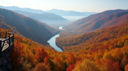
Fall Foliage Timing and Photography
Quebec’s fall color season compresses into roughly three weeks of peak brilliance, but that timing shifts dramatically by latitude and altitude. Location scouting requires understanding that Gatineau Hills peak earlier than Charlevoix, which peaks before the Gaspésie, creating a moving target for travelers trying to intercept maximum color.
Interactive map usage helps track the color progression in near-real-time, as provincial tourism offices maintain foliage status maps. However, altitude effects on color mean that mountainous regions display simultaneous variation—valleys still show green while summits blaze red and orange. Crowd avoidance spots require insider knowledge, as iconic locations like Mont-Tremblant or Jacques-Cartier National Park become parking lot nightmares during peak weekends.
Photography light contrast works differently in fall than summer. Lower sun angles create dramatic side-lighting, but overcast days (common in Quebec’s autumn climate) often produce better color saturation than harsh sunny conditions. Understanding leaf retention duration helps too—maples drop quickly after peaking, while oak and beech hold foliage longer, creating extended but less brilliant seasons.
Quebec’s road trip landscape rewards preparation as much as spontaneity. The province’s geographic extremes mean that strategies working perfectly on heritage routes create dangerous situations on remote highways, while seasonal timing shifts transform the same route from accessible to impossible. By understanding these fundamental distinctions and planning accordingly, you’ll spend less energy managing logistics and more time absorbing the experiences that drew you to these routes in the first place. The real journey begins when preparation becomes invisible—when your fuel calculations, cultural awareness, and timing strategies run quietly in the background, leaving you free to focus on the landscape rolling past your windshield.
The Dendrologist’s Guide: How to Scientifically Predict Peak Fall Foliage in Quebec
Predicting peak fall foliage in Quebec isn’t about calendar dates; it’s about scientifically reading the biological and atmospheric signs the trees send out. Elevation and microclimates create a staggered timeline,…
Read more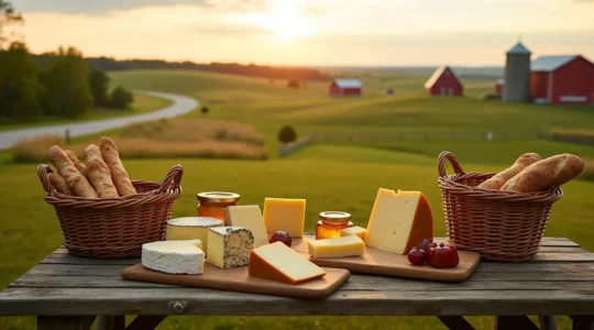
How to Plan a Cheese Tasting Road Trip in Quebec?
A successful Quebec cheese road trip isn’t about visiting the most places, but about mastering the logistics of taste and transport. Choose your region based on cheese density and pairing…
Read more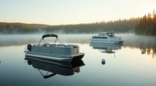
How to Rent a Pontoon or Houseboat in Quebec Without a Boating License?
Renting a boat in Quebec without a license legally designates you as the ‘temporary captain,’ with full financial and criminal liability. The rental boat safety checklist is not a formality;…
Read more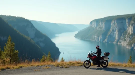
How to Master the Saguenay Fjord Route on a Motorcycle: A Tactical Guide
Mastering the Saguenay Fjord route is less about endurance and more about tactical preparation for its unique road DNA and logistical challenges. The South Shore (Rte 170) offers smooth tarmac…
Read more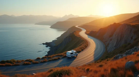
The Ultimate Guide to Planning Your Gaspésie Tour: How to Avoid Traffic and Crowds
The key to a stress-free Gaspésie tour isn’t just booking ahead; it’s mastering the predictable flow of tourist traffic. Move against the main current of RVs by planning drives during…
Read more
How to Drive the Chemin du Roy Without Losing Your Patience?
In summary: Stop treating the Chemin du Roy as a direct route; see it as a series of destinations. Use a “Leapfrog Strategy”: drive the efficient Highway 40 between regions,…
Read more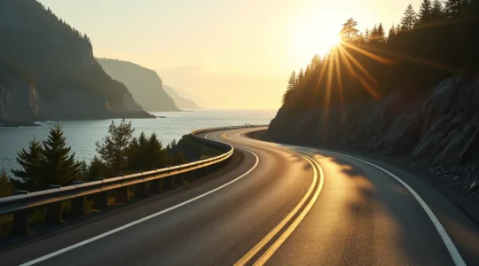
A Trucker’s Guide to Driving Route 138: Kegaska and Back, Safely
In summary: Treating the Route 138 drive like a casual trip is a mistake; approach it as a professional logistical operation. Fuel is your lifeline. Never let your tank drop…
Read more
How to Plan a Trip to Nunavik Without Spending a Fortune?
Planning a trip to Nunavik requires abandoning a tourist mindset and adopting a supply chain coordinator’s strategy to manage costs effectively. The extreme costs are driven by the logistical challenges…
Read more