Mastering the Saguenay Fjord route is less about endurance and more about tactical preparation for its unique road DNA and logistical challenges.
- The South Shore (Rte 170) offers smooth tarmac while the North Shore (Rte 172) demands technical skill with tighter, patched curves.
- Critical logistical gaps, like a 156 km stretch without fuel and unpredictable micro-climates, can trap unprepared riders.
Recommendation: Treat this ride as a technical mission: analyze the route, plan for every contingency, and respect the environmental hazards.
For any serious motorcyclist, a route is more than a line on a map; it’s a collection of challenges and rewards. The Saguenay Fjord route in Québec is often praised for its breathtaking scenery, but riders know that true enjoyment comes from understanding the road’s character. Many guides will tell you to simply “enjoy the view,” but they often gloss over the technical details that can make or break a motorcycle tour. They might mention the quaint villages or the chance to see whales, but they won’t dissect the pavement quality, the geometry of the curves, or the very real logistical hurdles you’ll face.
But what if the key to a truly memorable Fjord tour wasn’t just admiring the landscape, but mastering it? This guide takes a different approach. We’re treating this iconic route as a tactical mission. Instead of a simple travelogue, consider this your pre-ride briefing. We will dissect the road’s DNA, from the smooth, sweeping tarmac of the south shore to the technical, patched asphalt of the north. We will analyze the specific dangers, like the sharp, descending turns into L’Anse-Saint-Jean and the notorious fuel desert north of La Tuque.
This is not just about getting from point A to point B. It’s about executing a flawless ride where you’re prepared for every variable—be it a sudden downpour, a 150-kilometer gap between gas stations, or a moose standing in the twilight mist. By understanding the route’s every nuance, you transform a simple scenic tour into an exhilarating display of skill and preparation, allowing you to fully appreciate the stunning beauty of the Saguenay because you’re in complete control.
To help you prepare for this incredible journey, this guide breaks down the essential tactical knowledge you’ll need. We’ll cover everything from road surfaces and technical turns to fuel strategy and wildlife risks, ensuring you’re ready for whatever the Fjord throws at you.
Summary: A Rider’s Tactical Guide to the Saguenay Fjord
- Gravel or Tarmac: What Are the Road Conditions Around the Fjord?
- The Sharp Turns of L’Anse-Saint-Jean: Are They Dangerous for Beginners?
- Which Motels Offer Secure Parking for Motorcycles?
- Gas Station Gaps: How Far Can You Ride Without Refueling?
- Why Rain Gear Is Essential Even on Sunny Forecast Days?
- Zodiac or Big Boat: Which Is Best for Observing the Fjord’s Cliffs?
- The Moose Danger Zone: When to Stop Driving at Night?
- How to Explore the Saguenay Fjord by Water Without Breaking the Bank?
Gravel or Tarmac: What Are the Road Conditions Around the Fjord?
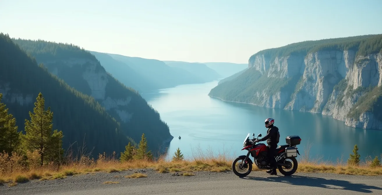
The first element of any ride plan is understanding the surface you’ll be on. The Saguenay Fjord route is not one uniform road; it’s a tale of two shores with distinctly different personalities. Your bike choice, speed, and even your line through a corner will depend on whether you’re on the north or south side of the water. The official Route du Fjord covers 235 kilometers, but the quality varies significantly within that distance. The South Shore, primarily Route 170, is generally the better of the two, offering smoother, well-maintained tarmac with wide, sweeping curves that are a dream for sport-touring bikes. It allows for a more fluid and faster-paced ride.
In contrast, the North Shore (Route 172) is more technical and demanding. While incredibly scenic, the road is narrower, the curves are tighter, and you’ll encounter more sections of patched and uneven asphalt. It requires more rider input, slower speeds, and constant attention to the road surface. Furthermore, seasonal damage from Québec’s harsh winters can lead to frost heave, creating unexpected bumps and dips, especially in the spring and early summer. It’s crucial to check for active “zones de travaux” (construction zones) before you depart, as these can introduce unexpected gravel patches that are particularly hazardous for street-oriented motorcycles.
Your Pre-Ride Road Condition Checklist: Saguenay Fjord Route
- Assess Route 170 (South Shore): Expect smooth, sweeping tarmac ideal for a fluid, sport-touring pace.
- Analyze Route 172 (North Shore): Prepare for tighter curves and patched asphalt sections requiring slower speeds and more technical input.
- Check Quebec 511: Before every ride, use the website or app to identify real-time “zones de travaux” and potential gravel patches.
- Inspect Remote Sections: Be extra vigilant on remote North Shore segments for signs of seasonal frost heave, especially in months following winter.
- Plan for the Unexpected: Regardless of the route, always be prepared for changing surfaces, from fresh pavement to worn-out sections.
The Sharp Turns of L’Anse-Saint-Jean: Are They Dangerous for Beginners?
The curves descending into the village of L’Anse-Saint-Jean are legendary among Québec riders, and for good reason. They are not “dangerous” in the hands of a prepared rider, but they are highly technical and unforgiving of mistakes. For a beginner, they can be intimidating. The primary challenge is a series of steep, descending, and often decreasing-radius turns. This means a corner tightens as you go through it, requiring precise throttle and brake control to avoid running wide. The combination of gravity pulling you downhill and the need to progressively increase your lean angle demands a high level of skill and concentration.
To navigate these turns safely, especially for less experienced riders, the key is to set your entry speed *before* the turn. Brake while the bike is still upright, look far through the corner to where you want to go, and apply gentle, steady throttle pressure once you’ve established your lean angle to stabilize the chassis. Aggressive braking or abrupt inputs mid-corner can easily unsettle the bike. Experienced riders from FortNine note that this area is a prime example of the Fjord’s micro-climates, where rain can appear suddenly, drastically reducing grip and adding another layer of complexity to these already demanding corners.
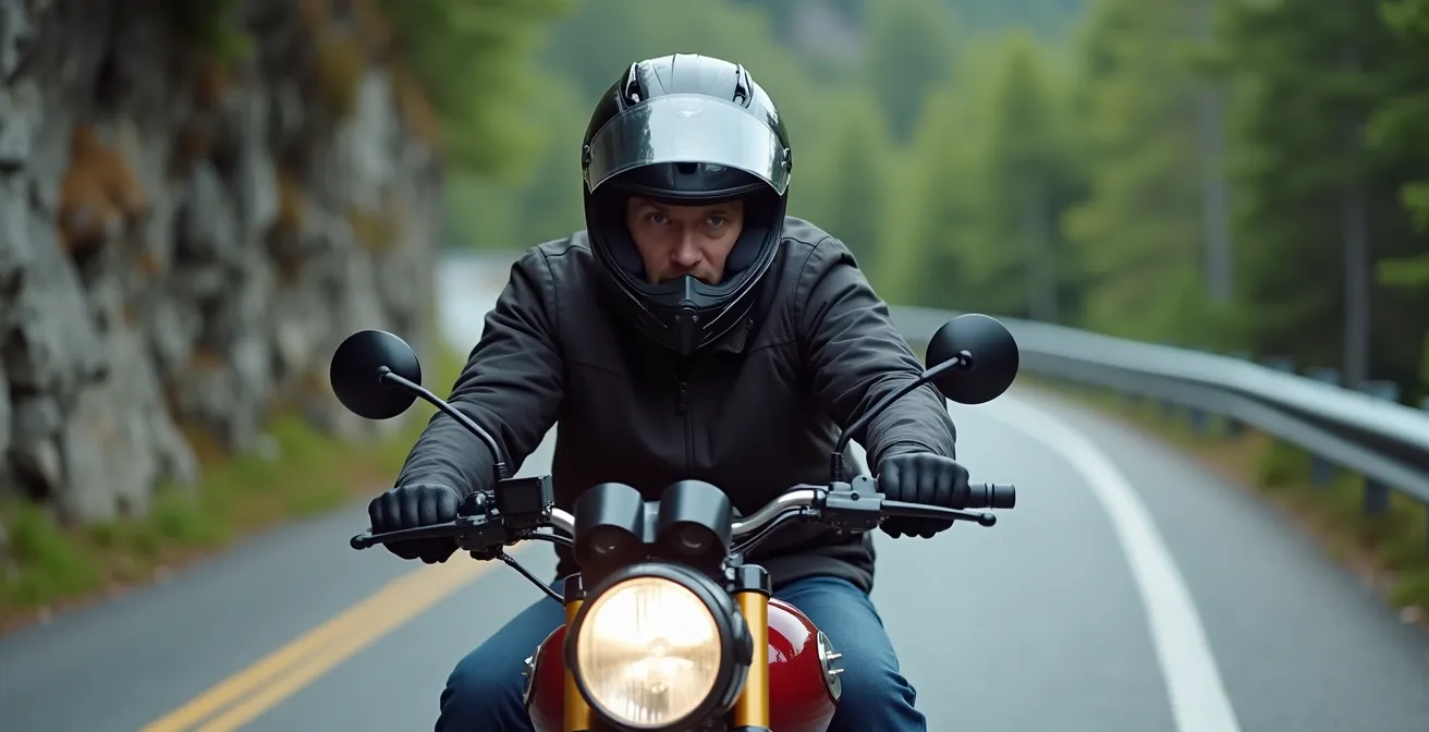
As the image above illustrates, proper body position—leaning with the bike and looking through the turn—is critical. These turns are a true test of a rider’s ability to read the road. For beginners, they should be approached with caution and seen as a learning experience, not a race. For seasoned riders, they are the technical highlight of the entire route, a rewarding puzzle of asphalt and gravity.
Which Motels Offer Secure Parking for Motorcycles?
After a long day of focused riding, knowing your motorcycle is parked safely is paramount. A standard hotel parking lot, with cars constantly moving and limited visibility, is not ideal. Along the Saguenay Fjord route, many accommodations understand the needs of riders and offer specific amenities. When booking, your primary concern should be secure and visible parking. Look for motels that offer ground-floor rooms with room-front parking, allowing you to keep an eye on your bike. Others may have well-lit lots with video surveillance or even designated, covered parking areas away from the main road traffic.
As one rider noted in their trip report, the hospitality in the region is a major plus. In a review of their stay at Auberge Les Sources in Pointe-au-Pic, they mentioned:
Prices are reasonable and everyone we met was friendly and welcoming. For our third and final night, we had a reservation at Auberge Les Sources in Pointe-au-Pic, just west of La Malbaie. I would say it was my favourite of the three, but they were all my favourite.
– 650thumper.blog, Saguenay Trip Report
This highlights that rider-friendly places often combine good amenities with a welcoming attitude. Many local Auberge and B&B owners are riders themselves or are very familiar with the route, offering invaluable local advice. When choosing your lodging, don’t hesitate to call ahead and ask specifically about their motorcycle parking situation. The following table, based on information from official Québec tourism guides, provides a general overview of what to expect in key locations.
| Location | Accommodation Type | Parking Features | Biker Amenities |
|---|---|---|---|
| Tadoussac | Various Motels | Well-lit lots, video surveillance | Ground-floor rooms, cleaning supplies |
| L’Anse-Saint-Jean | Auberges/B&Bs | Covered parking available | Local route advice from owners |
| Saguenay (La Baie) | Hotels/Motels | Secure lots away from main road | Room-front parking options |
| Pointe-au-Pic | Auberge Les Sources | Direct room access parking | Special sunrooms for gear storage |
Gas Station Gaps: How Far Can You Ride Without Refueling?
There is no worse feeling on a motorcycle tour than the sinking realization that you’ve passed the point of no return with a dwindling fuel tank. On the Saguenay Fjord route, this is not a hypothetical risk; it’s a certainty if you don’t plan ahead. While the South Shore is reasonably serviced, the northern part of the loop contains one of Québec’s most notorious logistical blackouts for fuel. Specifically, when heading north from La Tuque on Route 155, you will encounter a well-marked but intimidating section where a highway warning indicates no gas is available for 156 kilometers. For many motorcycles, especially those with smaller tanks or being ridden aggressively, this distance is at or beyond their maximum range.
Running out of fuel here is not an option; cell service is spotty, and traffic can be sparse. Therefore, a rigid fuel strategy is non-negotiable. The rule is simple: never pass a gas station with a half-empty tank, especially on the North Shore or connecting routes. La Tuque should be considered a mandatory full-tank stop before heading north. Similarly, Tadoussac is your last reliable fuel point before venturing onto the more remote sections of Route 172. It’s also critical to remember that outside the peak tourist months of July and August, many small village gas stations operate on reduced hours and may be closed in the evening or on Sundays.
For absolute peace of mind, especially if your bike’s fuel light typically comes on before the 150 km mark, carrying a 1-liter emergency fuel bottle is a wise and inexpensive insurance policy. Calculating your bike’s true range under touring conditions (loaded with gear, fighting headwinds) is a vital piece of data for this trip. Don’t rely on the manufacturer’s stated range; know your own numbers.
Why Rain Gear Is Essential Even on Sunny Forecast Days?
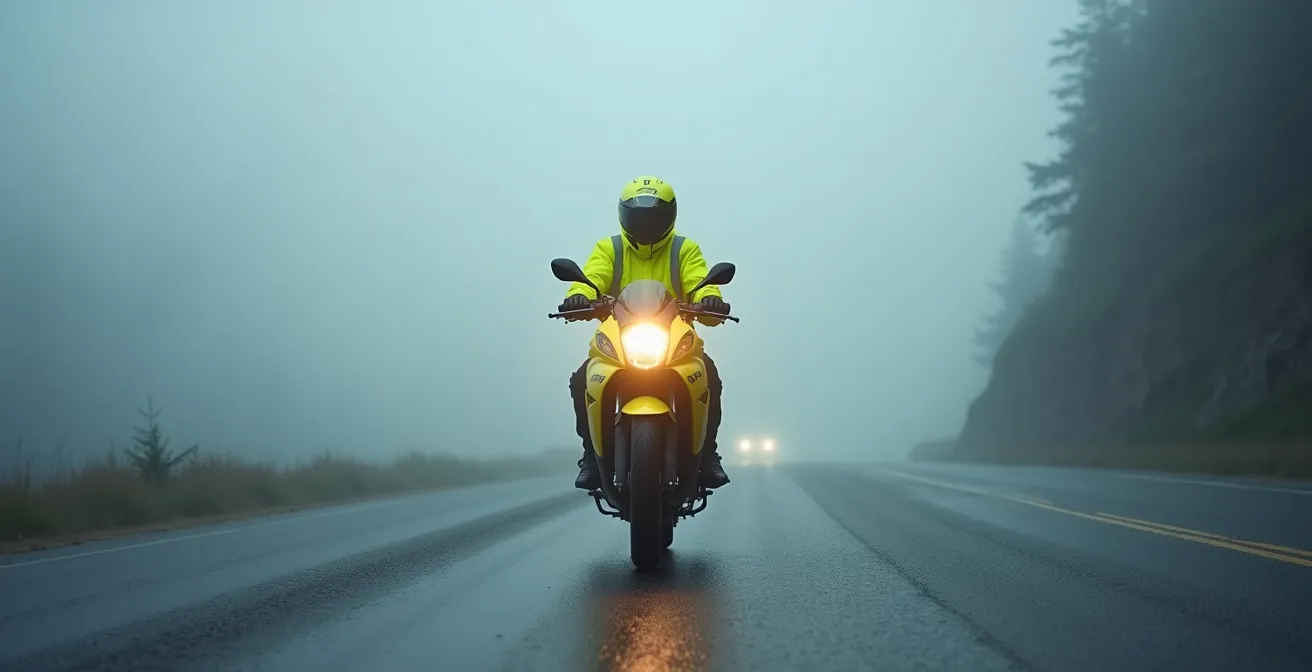
In the Saguenay Fjord region, a sunny forecast is more of a suggestion than a guarantee. The area is a classic example of a coastal micro-climate, where the interaction between the cold water of the Fjord and the surrounding high cliffs creates its own weather system. A perfectly clear, sunny day can turn into a torrential downpour in a matter of minutes, with little to no warning. Being caught without rain gear is not just uncomfortable; it’s dangerous. Wet gear leads to a rapid drop in body temperature, causing fatigue, delayed reactions, and a loss of focus—all critical faculties for navigating technical roads.
The experience of many riders, as documented by FortNine, tells a cautionary tale of being surprised by sudden, intense rain after leaving a sunny village. One moment you’re enjoying a beautiful sunset, the next you’re in a storm “harder than I ever thought possible.” This is not an exaggeration; it’s the reality of riding in this region. This unpredictability is why experienced riders here have a certain confidence in their own preparations, as pithily stated by FortNine’s Ryan Kluftinger:
I can predict the conditions better than a meteorologist with a crystal ball.
– Ryan Kluftinger, FortNine Saguenay motorcycle trip report
This isn’t arrogance; it’s the wisdom of assuming the worst and being prepared for it. Your rain gear is not just for rain; it’s also an essential wind-breaking layer that helps regulate your body temperature. On top of that, choosing high-visibility rain gear dramatically increases your safety, making you more visible to other drivers in the fog, mist, and heavy spray that often accompany these sudden storms.
Packing rain gear is not about expecting a bad day; it’s a tactical decision to ensure that a sudden change in weather doesn’t ruin your ride or compromise your safety. It should be the last thing you consider leaving behind to save space.
Zodiac or Big Boat: Which Is Best for Observing the Fjord’s Cliffs?
Exploring the Saguenay Fjord from the water offers a perspective a motorcycle simply cannot provide. The scale of the cliffs and the potential for wildlife sightings are best appreciated from below. The two main options for riders are a fast, agile Zodiac or a larger, more comfortable cruise boat (“croisière”). The best choice depends entirely on your schedule, budget, and desired experience. The Zodiac offers a thrilling, intimate, and fast-paced adventure. You are at water level, feeling every wave, and can get incredibly close to the cliffs and potentially to wildlife like seals and whales. A typical Zodiac tour lasts 1-2 hours, making it easier to fit into a tight riding schedule.
The big boat, on the other hand, is a more relaxed and leisurely experience. These tours last 3 hours or more, offering a stable platform with amenities like restrooms, food, and protection from the elements. The elevated decks provide a different, more panoramic viewing angle of the cliffs. However, this option consumes a significant portion of your riding day. A practical consideration for either choice is your gear. Some operators may offer storage, but you should confirm this beforehand. The last thing you want is to leave your helmet, jacket, and luggage unattended on a public dock. As one tour operator mentions, many riders spend a night in Tadoussac to specifically accommodate a zodiac trip, which simplifies the gear logistics.
The following table breaks down the key differences to help you make a tactical decision that fits your ride plan.
| Feature | Zodiac | Big Boat (Croisière) |
|---|---|---|
| Duration | 1-2 hours | 3+ hours |
| Experience | Fast, thrilling, intimate | Relaxed with amenities |
| Schedule Flexibility | Fits tight riding schedule | Takes large chunk of day |
| Wildlife Viewing | Close water-level views | Elevated deck views |
| Cost | Moderate-High | Higher |
Key Takeaways
- The Fjord Route is a tale of two shores: the fast, smooth tarmac of Route 170 and the technical, demanding curves of Route 172.
- Logistical planning is non-negotiable, with a 156 km fuel desert and unpredictable micro-climates being the top two challenges.
- Safety relies on respecting environmental hazards: always carry rain gear and cease riding before sunset to avoid peak wildlife activity.
The Moose Danger Zone: When to Stop Driving at Night?
Of all the potential hazards on the Saguenay Fjord route, a collision with wildlife is the most severe. While deer and porcupines pose a significant threat, the greatest danger comes from moose. An adult moose can weigh over 500 kg, and hitting one on a motorcycle is almost always catastrophic. The risk of a wildlife encounter is not uniform throughout the day; wildlife collision risk is highest during the period from sunset to sunrise. During these twilight and nighttime hours, animals are most active, and a rider’s visibility is severely compromised, even with excellent headlights.
For this reason, the most important safety rule for this trip is to be parked before sunset. This is not a soft recommendation; it should be a hard-and-fast rule in your ride plan. Use a civil twilight calculator for the specific date of your trip to know the exact time you need to be off the road. Certain areas are known high-risk zones, particularly along Route 172 near Sacré-Coeur and the entrance to Monts-Valin National Park. In these forested, sparsely populated areas, the chances of encountering a moose on the road at dusk are exceptionally high.
If you are ever unavoidably caught out after dark, your tactics must change immediately. Reduce your speed significantly, use your high beams on straight sections (being courteous to other drivers), and constantly scan the roadsides for the tell-tale eye-shine reflection from your lights. Auxiliary lights, if your bike is equipped with them, can be a lifesaver by illuminating the ditches and forest edge where animals often stand before crossing. But these are last-resort measures. The only truly safe strategy is to plan your day’s mileage so that you arrive at your destination with plenty of daylight to spare.
How to Explore the Saguenay Fjord by Water Without Breaking the Bank?
While dedicated boat tours offer an incredible experience, they can also be expensive and time-consuming, which might not fit every rider’s budget or schedule. Fortunately, there are several ways to experience the grandeur of the Fjord from the water without a significant financial outlay. The single best budget option is a built-in part of the route itself: the ferry.
Case Study: The Ultimate Budget Fjord Experience
Riders completing the Fjord Route loop must cross the mouth of the Saguenay River between Baie-Sainte-Catherine and Tadoussac. The mandatory ferry for this crossing is completely free for all vehicles, including motorcycles. This 10-minute journey provides a stunning, ground-level view of the Fjord’s immense mouth and is a prime location for spotting beluga whales, which often frequent the area. It effectively serves as a mini-cruise that costs nothing and is an integral part of the ride.
Beyond the ferry, other low-cost options exist for those who want a more intimate experience. In L’Anse-Saint-Jean, you can rent a sea kayak for an hour or two right from the beach. This allows you to paddle along the base of the towering cliffs at your own pace, offering a truly personal and silent perspective that no motorized boat can match. It’s an excellent way to stretch your legs and engage with the environment directly after a few hours on the bike.
Finally, don’t underestimate the power of free viewpoints from the land. Well-placed stops like the Halte-Belvédère in Sacré-Coeur or the panoramic vistas within the Baie-Éternité sector of the Saguenay Fjord National Park (park entry fee may apply) provide breathtaking, elevated views of the water for the cost of a simple stop. By combining the free ferry ride with a short kayak rental or a visit to a scenic lookout, you can have a rich and varied water-based experience without breaking your tour budget.
Now that you have the complete tactical briefing, from road surface analysis to budget-friendly excursions, the final step is to synthesize this knowledge into your own personalized ride plan. Start mapping your daily mileage, pre-booking your rider-friendly lodging, and preparing your gear for every contingency. A successful Saguenay Fjord tour is your reward for meticulous preparation.